
Introduction:
In times of crisis and disaster, timely and accurate information is crucial for effective emergency response. Traditional methods of data collection and analysis can often be slow and resource-intensive, leading to delays in decision-making and allocation of resources. However, advancements in technology have revolutionized the way emergency responders collect, analyze, and utilize data during emergencies. One such innovation is crisis mapping, a powerful tool that leverages geographic information systems (GIS), satellite imagery, and crowdsourced data to create dynamic maps that inform and guide emergency response efforts. In this article, we will explore the role of crisis mapping and data analysis in modern emergency response strategies, examining how technology is transforming the way we prepare for and respond to disasters.
The Evolution of Emergency Response:
Historically, emergency response efforts relied heavily on manual data collection methods, such as paper surveys, field assessments, and phone interviews. While these methods provided valuable information, they were often time-consuming, labor-intensive, and prone to errors. In recent years, however, the advent of technology has revolutionized the field of emergency response, enabling responders to collect, analyze, and disseminate data in real-time.
Research Article: Zook, M., et al. (2010). “The crowdsourcable database: A new research method for disaster social science.” PLOS currents.
Crisis Mapping: A Game-Changer in Emergency Response:
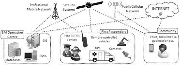
Crisis mapping refers to the process of collecting, visualizing, and analyzing geospatial data to understand and respond to emergencies. By harnessing the power of geographic information systems (GIS), satellite imagery, and crowdsourced data, crisis mapping platforms provide emergency responders with valuable insights into the scope, scale, and impact of disasters in real-time. These platforms allow users to create dynamic maps that display critical information such as affected areas, population density, infrastructure damage, and resource distribution points.
Research Article: Meier, P. (2015). “Digital humanitarians: How big data is changing the face of humanitarian response.”
Applications of Crisis Mapping and Data Analysis:
Early Warning Systems:
- Crisis mapping and data analysis play a crucial role in early warning systems, allowing emergency responders to anticipate and prepare for potential disasters before they occur. By monitoring key indicators such as weather patterns, seismic activity, and social media chatter, responders can identify emerging threats and mobilize resources to mitigate their impact.
Research Article: Keim, M. E. (2008). “Building human resilience: The role of public health preparedness and response as an adaptation to climate change.”
Resource Allocation:
- During emergencies, effective resource allocation is essential for delivering aid and support to affected communities. Crisis mapping and data analysis enable responders to identify areas of greatest need, prioritize response efforts, and optimize the distribution of resources such as food, water, medical supplies, and shelter.
Research Article: Chan, E. Y. Y., et al. (2019). “Humanitarian needs assessments and decision making in the 21st century: Lessons from the field.”
Damage Assessment:
- After a disaster strikes, accurate damage assessment is crucial for assessing the extent of the impact and planning recovery efforts. Crisis mapping allows responders to visualize the extent of damage to infrastructure, buildings, and natural resources, enabling them to prioritize areas for intervention and allocate resources accordingly.
Research Article: Kennedy, P. W., et al. (2013). “Damage assessment: A key component of a community disaster response.”
Conclusion:
Crisis mapping and data analysis have emerged as invaluable tools in modern emergency response strategies, providing responders with real-time information and actionable insights to guide their efforts. By harnessing the power of technology, emergency responders can anticipate threats, allocate resources, and coordinate response efforts more effectively, ultimately saving lives and minimizing the impact of disasters on communities. As technology continues to evolve, the potential of crisis mapping and data analysis to inform emergency response strategies will only continue to grow, ushering in a new era of preparedness and resilience in the face of disaster.